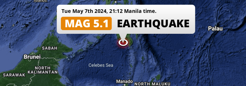
A significant Magnitude 5.0 earthquake struck in the Sulawesi Sea 70 kilometer from General Santos, The Philippines in the evening of Tuesday May 7th, 2024.
Felt the earthquake? Share this article: 


Earthquake Summary
This earthquake hit under water in the Sulawesi Sea, 23 kilometers (14 mi) off the coast of The Philippines, 70 kilometer southwest of General Santos in Soccsksargen. The center of this earthquake had a quite shallow depth of 52 km. Shallow earthquakes usually have a larger impact than earthquakes deep in the earth.
| Date and Time: | May 7, 2024 09:12PM (Manila Time) - May 7, 2024 13:12 Universal Time. |
|---|---|
| Location: | 70 km SW of General Santos, Soccsksargen, The Philippines. Coordinates 5°43'52"N 124°39'60"E. |
| Map: | 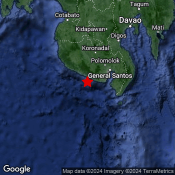 Map of area around epicenter. Click to open in Google Maps. |
| Magnitude: | MAG 5.0 Detected by 11 stations. Maximum Error Range ±0.093 . |
| Depth: | 52 km (32 mi) A quite shallow depth. |
| Tsunami Risk: | Low tsunami risk Earthquakes under MAG-6.5 do not usually cause tsunami's. Always stay cautious - More info here. |
Nearby towns and cities
This earthquake may have been felt in The Philippines . Located 55 kilometer (34 mi) south of the epicenter of this earthquake, Lake Sebu (Soccsksargen, The Philippines) is the nearest significant population center.
Multiple major population centers exist within 300km of the earthquake that struck today. General Santos is located 70 km to the north-east. Budta is located 166 km to the north. Malingao is located 160 km to the north.
A complete list of nearby places is included below.
Overview of nearby places
| Distance | Place |
|---|---|
| 55 km (34 mi) N from epicenter |
Lake Sebu Soccsksargen, The Philippines. |
| 60 km (37 mi) E from epicenter |
Glan Soccsksargen, The Philippines. |
| 70 km (43 mi) NE from epicenter |
General Santos Soccsksargen, The Philippines. |
| 70 km (43 mi) NE from epicenter |
Polomolok Soccsksargen, The Philippines. |
| 72 km (45 mi) N from epicenter |
Surallah Soccsksargen, The Philippines. |
| 74 km (46 mi) ENE from epicenter |
Malapatan Soccsksargen, The Philippines. |
| 74 km (46 mi) NNE from epicenter |
Tupi Soccsksargen, The Philippines. |
| 78 km (48 mi) N from epicenter |
Bañga Soccsksargen, The Philippines. |
| 80 km (50 mi) ENE from epicenter |
Alabel Soccsksargen, The Philippines. |
| 88 km (55 mi) NNE from epicenter |
Koronadal Soccsksargen, The Philippines. |
| 91 km (57 mi) NE from epicenter |
Maluñgun Soccsksargen, The Philippines. |
| 100 km (62 mi) N from epicenter |
Isulan Soccsksargen, The Philippines. |
| 106 km (66 mi) N from epicenter |
Laguilayan Soccsksargen, The Philippines. |
| 107 km (66 mi) N from epicenter |
Tacurong Soccsksargen, The Philippines. |
| 111 km (69 mi) N from epicenter |
Buluan Rehiyong Autonomo sa Muslim na Mindanao, The Philippines. |
| 128 km (80 mi) NNW from epicenter |
Maganoy Rehiyong Autonomo sa Muslim na Mindanao, The Philippines. |
| 128 km (80 mi) NE from epicenter |
Santa Maria Davao, The Philippines. |
| 129 km (80 mi) NNE from epicenter |
Magsaysay Davao, The Philippines. |
| 129 km (80 mi) NE from epicenter |
Malita Davao, The Philippines. |
| 132 km (82 mi) NNE from epicenter |
Bansalan Davao, The Philippines. |
| 137 km (85 mi) NNE from epicenter |
Digos Davao, The Philippines. |
| 150 km (93 mi) NNE from epicenter |
Kidapawan Soccsksargen, The Philippines. |
| 154 km (96 mi) N from epicenter |
Kabacan Soccsksargen, The Philippines. |
| 160 km (99 mi) NNW from epicenter |
Pagaluñgan Rehiyong Autonomo sa Muslim na Mindanao, The Philippines. |
| 160 km (99 mi) N from epicenter |
Malingao Soccsksargen, The Philippines. |
| 163 km (101 mi) N from epicenter |
Midsayap Soccsksargen, The Philippines. |
| 166 km (103 mi) N from epicenter |
Budta Rehiyong Autonomo sa Muslim na Mindanao, The Philippines. |
| 172 km (107 mi) NNW from epicenter |
Cotabato Rehiyong Autonomo sa Muslim na Mindanao, The Philippines. |
| 182 km (113 mi) NE from epicenter |
Davao Davao, The Philippines. |
| 187 km (116 mi) NNW from epicenter |
Parang Rehiyong Autonomo sa Muslim na Mindanao, The Philippines. |
| 189 km (117 mi) NE from epicenter |
Samal Davao, The Philippines. |
| 197 km (122 mi) NE from epicenter |
Lupon Davao, The Philippines. |
| 208 km (129 mi) NNE from epicenter |
Panabo Davao, The Philippines. |
| 217 km (135 mi) N from epicenter |
Wao Rehiyong Autonomo sa Muslim na Mindanao, The Philippines. |
| 219 km (136 mi) NE from epicenter |
Mati Davao, The Philippines. |
| 220 km (137 mi) N from epicenter |
Don Carlos Northern Mindanao, The Philippines. |
| 227 km (141 mi) NNE from epicenter |
Quezon Northern Mindanao, The Philippines. |
| 229 km (142 mi) N from epicenter |
Maramag Northern Mindanao, The Philippines. |
| 229 km (142 mi) NNE from epicenter |
Magugpo Poblacion Davao, The Philippines. |
| 246 km (153 mi) N from epicenter |
NIA Valencia Northern Mindanao, The Philippines. |
| 256 km (159 mi) N from epicenter |
Marawi City Rehiyong Autonomo sa Muslim na Mindanao, The Philippines. |
| 267 km (166 mi) NE from epicenter |
Compostela Davao, The Philippines. |
| 268 km (167 mi) NNW from epicenter |
Muricay Zamboanga Peninsula, The Philippines. |
| 270 km (168 mi) NNW from epicenter |
Pagadian Zamboanga Peninsula, The Philippines. |
| 275 km (171 mi) N from epicenter |
Mantampay Northern Mindanao, The Philippines. |
| 275 km (171 mi) N from epicenter |
Malaybalay Northern Mindanao, The Philippines. |
| 278 km (173 mi) NNW from epicenter |
Tangub Northern Mindanao, The Philippines. |
| 278 km (173 mi) NNE from epicenter |
Monkayo Davao, The Philippines. |
| 282 km (175 mi) N from epicenter |
Iligan City Soccsksargen, The Philippines. |
| 282 km (175 mi) N from epicenter |
Iligan Northern Mindanao, The Philippines. |
| 284 km (176 mi) NNW from epicenter |
Ozamiz City Northern Mindanao, The Philippines. |
| 297 km (185 mi) NNE from epicenter |
Veruela Caraga, The Philippines. |
Shaking reported by 3 people
People that feel an earthquake may report their experience to the US Geographic Survey. Currently, 3 people have reported shaking in 2 places in Philippines.We keep updating this article as more ground reports become available. You may report that you felt this earthquake here.
Places with most reports:
- Buayan, Southern Mindanao, Philippines: 2 people.
- Davao, Southern Mindanao, Philippines: 1 person.
Aftershocks detected
This main shock was prefaced by 1 smaller foreshock. Nearby this earthquake a foreshock struck 24 mins earlier. It measured a magnitude of 3
Overview of foreshocks and aftershocks
| Classification | Magnitude | When | Where |
|---|---|---|---|
| Foreshock | M 3.0 |
24 mins earlier May 7, 2024 08:49PM (Manila Time) | 87 km (54 mi) ENE from Main Shock. |
| Main Shock This Earthquake |
M 5.0 |
May 7, 2024 09:12PM (Manila Time) | - |
More earthquakes coming?
Aftershocks are usually at least 1 order of magnitude less strong than main shocks. The more time passes, the smaller the chance and likely strength of any potential aftershocks.
The chance that a significant earthquake like this one is followed by an even larger earthquake is not so large. On average, scientists estimate a 94% chance that a major earthquake will not be followed by an even larger one. It is still adviced to be aware of this risk
Read: How to Stay Safe during an Earthquake (cdc.gov).Earthquakes like this happen often in the region
Earthquakes of this strength are very common in the region. This is the strongest earthquake to hit since April 11th, 2024, when a 5.2 magnitude earthquake hit 269 km (167 mi) further north-east. An even stronger magnitude 7.3 earthquake struck on January 10th, 2017.
In total, 274 earthquakes with a magnitude of 5 or higher have been registered within 300km (186 mi) of this epicenter in the past 10 years. This comes down to an average of once every 13 days.
Low tsunami risk
Based on early data it appears this earthquake was not strong enough (lower than MAG-6.5) to be likely to cause destructive tsunami's. However this earthquake appeared to have hit at a shallow depth under sea, so stay cautious and monitor advice from local authorities.
Tsunami Risk Factors
| Factor | Under Sea? | MAG-6.5 or stronger? | Shallow depth? |
|---|---|---|---|
| Explanation | Almost all tsunami's are caused by earthquakes with their epicenter under sea or very near the sea. However stay cautious in coastal areas as earthquakes on land may cause landslides into sea, potentially still causing a local tsunami. | Under MAG 6.5: Very unlikely to cause a tsunami. MAG 6.5 to 7.5: Destructive tsunami's do occur, but are uncommon. Likely to observe small sea level changes. MAG 7.6+: Earthquakes with these magnitudes might produce destructive tsunami's. |
Most destructive tsunami's are caused by shallow earthquakes with a depth between 0 and 100km under the surface of the earth. Deeper tsunami's are unlikely to displace to ocean floor. |
| This Earthquake | This earthquake appears to have struck under the sea. | Not this earthquake. This earthquake had a magnitude of 5. Earthquakes of this strength are unlikely to trigger a tsunami. |
This earthquake occurred at a depth of of 52 km (32 mi). Earthquakes this shallow could trigger a tsunami. |
Sources
Last updated 19/05/24 14:08 (). As more information on this earthquake becomes available this article will be updated. This article is automatically composed based on data originating from multiple sources.
- US Geographic Society (USGS): Earthquake us6000mwy9
- European-Mediterranean Seismological Centre (EMSC): Earthquake 20240507_0000130
- Geonames.org: World Cities Database
- Google Maps: Static API
- Earthquakelist.org: Historic Earthquakes Database
Share this article:
